May 14, 1804 marked the beginning of the Lewis and Clark Expedition.[1] The expedition’s objective was to discover and study the scientific data on animals and plant as well as the Native tribes living in the area. Those were the objectives outlined by President Jefferson, but the underlying reason for the whole expedition was to find a direct waterway leading to the West Coast’s Pacific Ocean.[2] The journey took about two and a half years and consisted of 33 people. Most were volunteers.[3] There was only one casualty that occurred and it was the death of Charles Floyd on August 20, 1804. The rest of the journey had many obstacles, but Lewis and Clark overcame them all.
Before the journey began, many preparations were made. Meriwether Lewis was chosen to lead the expedition because of his expertise of the west as well as being an experienced leader of the Army. William Clark was chosen by Lewis to be his co-captain. The two established the Corps of Discovery which consisted of 33 men. Sacagawea was also captured five years earlier and was to be made an interpreter throughout the expedition. The expedition used Lewis's 55-foot long keelboat and two smaller boats called pirogues to carry their supplies and equipment.[4] Once the preparations were made, they were to embark on their journey on May 14, 1804.
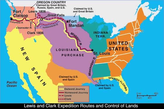
On this journey, Lewis and Clark followed the Missouri River all the way up towards the northwest. The first fork in the river he discovered, he named one of the forks, the Marias River and continued to follow the other fork. The other fork to an area now known as the Great Falls. They start continuing westward in hopes of finding the Pacific Ocean. Eventually, they reached the Three Forks of the Missouri. It was named Jefferson, Gallatin, and Madison.[5] Following the river only lead to more mountains. At this point, Lewis realized there was no easy water route leading to the West Coast. As they were in the mountainous areas, they encounter the Shoshone, Sacagawea’s people. Lewis and Clark continued to move on west and encounter the Nez Perce Indians. They were hospitalized by the Nez Perce and continued to set out on their journey. Lewis and Clark decided to split their people to confirm that there really is no easy water route to the west coast. Lewis and Clark reached the Pacific Ocean where they built Fort Clatsop in 1805.[6] Lewis and Clark departed Fort Clatsop to head back home. Lewis went North on along the Missouri River while Clark went south along the Yellowstone River. Lewis’s group encountered the Blackfeet Indians and saw that they were hostile. Lewis was forced to kill two of them. This was the only violent incident throughout the whole expedition. Once reaching North Dakota, Lewis and Clark rendezvoused and arrives back to St. Louis.
The Lewis and Clark expedition confirmed that there was no easy water route to the Pacific Ocean. Although this expedition did not find what it wanted, it still provided the U.S with information on the undiscovered area. It also gave knowledge to the animals and plants living in the area and the Native American tribes who lived there.
[1] National Park Service. “The Journey – Lewis and Clark Expedition: A National Register of History Places Travel Itenerary.” NPS.gov http://www.cr.nps.gov/nr/travel/lewisandclark/journey.htm
[2] Geography. “A History and Overview of Lewis and Clark’s Legendary Expedition.” About.com http://geography.about.com/od/historyofgeography/a/lewisclark.htm
[3] Ibid.
[4] National Park Service. “The Journey – Lewis and Clark Expedition: A National Register of History Places Travel Itenerary.” NPS.gov http://www.cr.nps.gov/nr/travel/lewisandclark/journey.htm
[5] Ibid.
[6] Ibid.
Before the journey began, many preparations were made. Meriwether Lewis was chosen to lead the expedition because of his expertise of the west as well as being an experienced leader of the Army. William Clark was chosen by Lewis to be his co-captain. The two established the Corps of Discovery which consisted of 33 men. Sacagawea was also captured five years earlier and was to be made an interpreter throughout the expedition. The expedition used Lewis's 55-foot long keelboat and two smaller boats called pirogues to carry their supplies and equipment.[4] Once the preparations were made, they were to embark on their journey on May 14, 1804.
On this journey, Lewis and Clark followed the Missouri River all the way up towards the northwest. The first fork in the river he discovered, he named one of the forks, the Marias River and continued to follow the other fork. The other fork to an area now known as the Great Falls. They start continuing westward in hopes of finding the Pacific Ocean. Eventually, they reached the Three Forks of the Missouri. It was named Jefferson, Gallatin, and Madison.[5] Following the river only lead to more mountains. At this point, Lewis realized there was no easy water route leading to the West Coast. As they were in the mountainous areas, they encounter the Shoshone, Sacagawea’s people. Lewis and Clark continued to move on west and encounter the Nez Perce Indians. They were hospitalized by the Nez Perce and continued to set out on their journey. Lewis and Clark decided to split their people to confirm that there really is no easy water route to the west coast. Lewis and Clark reached the Pacific Ocean where they built Fort Clatsop in 1805.[6] Lewis and Clark departed Fort Clatsop to head back home. Lewis went North on along the Missouri River while Clark went south along the Yellowstone River. Lewis’s group encountered the Blackfeet Indians and saw that they were hostile. Lewis was forced to kill two of them. This was the only violent incident throughout the whole expedition. Once reaching North Dakota, Lewis and Clark rendezvoused and arrives back to St. Louis.
The Lewis and Clark expedition confirmed that there was no easy water route to the Pacific Ocean. Although this expedition did not find what it wanted, it still provided the U.S with information on the undiscovered area. It also gave knowledge to the animals and plants living in the area and the Native American tribes who lived there.
[1] National Park Service. “The Journey – Lewis and Clark Expedition: A National Register of History Places Travel Itenerary.” NPS.gov http://www.cr.nps.gov/nr/travel/lewisandclark/journey.htm
[2] Geography. “A History and Overview of Lewis and Clark’s Legendary Expedition.” About.com http://geography.about.com/od/historyofgeography/a/lewisclark.htm
[3] Ibid.
[4] National Park Service. “The Journey – Lewis and Clark Expedition: A National Register of History Places Travel Itenerary.” NPS.gov http://www.cr.nps.gov/nr/travel/lewisandclark/journey.htm
[5] Ibid.
[6] Ibid.
